Storm Claudia Floods Parts of England and Wales as Met Office Issues Amber Warning on November 14, 2025
- Nov, 29 2025
- 0 Comments
- Finnegan Callaghan
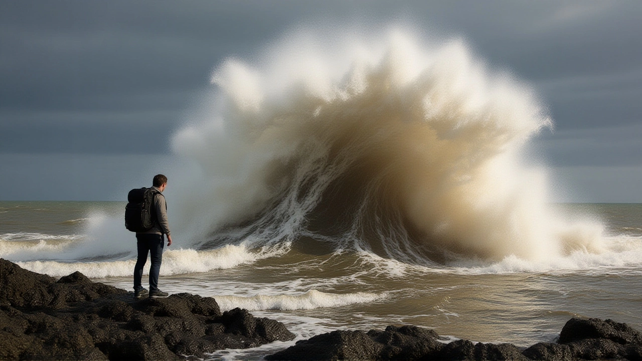
When the Met Office dropped an amber warning for parts of England and Wales on November 14, 2025, residents didn’t just see rain—they saw rivers swelling, roads vanishing, and power lines swaying under gusts that sounded like freight trains. Storm Claudia, named by AEMET (Spain’s State Meteorological Agency) on November 10, had arrived with a vengeance, dumping over 100 millimeters of rain in some areas within 24 hours. It wasn’t just wet. It was catastrophic. And it was only the latest in a string of extreme weather events shaking the UK this autumn.
How Storm Claudia Turned a Rainy Friday Into a Disaster
The afternoon forecast on November 14, delivered live by Alex Deakin on the Met Office’s YouTube channel, was chilling in its simplicity: "We have amber warnings in place. Heavy and persistent rain is expected to cause flooding." No fluff. No sugarcoating. Just facts—and urgency. Viewers watching the live stream from Exeter saw meteorologists Annie and Alex point to a map pulsing red across central England. The heaviest bands were locked over the west of the Pennines, stretching toward Norfolk. "It just continues to bring pulses of heavy rain," Annie said, her voice tight. "Another 100 millimeters could fall. That’s nearly four inches in less than a day. Rivers won’t hold it. Sewers won’t cope." By 5 p.m., the River Severn had breached its banks near Shrewsbury. In Herefordshire, emergency crews were pulling cars from submerged driveways. Schools in Stoke-on-Trent closed early. The Met Office’s UK Storm Centre confirmed this was the third named storm of the 2025-26 season—after Storm Amy (October 3–4, 2025) and Storm Benjamin (named October 22, 2025, by Meteo France). The naming system, coordinated between the UK, Ireland, and the Netherlands, is no longer ceremonial. It’s a survival tool.The Aftermath: Cold, Snow, and More Wind
By November 20, the skies had cleared—but the danger hadn’t passed. In fact, it had changed form. Clare Nasir delivered a grim forecast: "Frequent wintry showers will affect Scotland and many coasts of England. Snow is possible." An amber warning for snow was issued for the northeast, particularly north and east Yorkshire. Up to 25 centimeters—nearly a foot—of snow was expected on higher ground. Roads became impassable. Power cuts hit over 12,000 homes in Northumberland alone. One resident in the Yorkshire Dales told a local paper: "I’ve lived here 40 years. I’ve seen snow. But never this fast. The grid just… gave up." Then came the wind. On November 27, 2025, the Met Office issued a yellow warning for western and northern Scotland, with gusts of 60–70 mph. By midnight, those gusts hit 75 mph near the Hebrides. Ferries were canceled. Roofs were ripped off in Oban. The Met Office’s official release at 11:45 UTC noted the system was "an area of low-pressure approaching from the Atlantic"—a phrase that, by now, had become a grim mantra.Why This Season Feels Different
It’s not just the frequency. It’s the timing. Storm Amy hit just after the autumn equinox. Benjamin came before Halloween. Claudia struck the week before Thanksgiving. And now, snow in late November? That’s two weeks earlier than the 30-year average. Climate scientists at the University of Reading told the BBC: "We’re not seeing more storms—but we’re seeing them hit harder, faster, and in places we used to think were safe." The Met Office’s own data shows that since 2010, the number of amber or red flood warnings issued in November has more than doubled. And this year? It’s on track to be the worst on record.
What’s Next? The Pattern Won’t Stop
The Met Office has already flagged another low-pressure system forming over the Atlantic, possibly bringing more rain to the west coast by December 3. The UK’s flood defense budget, already stretched thin after last winter’s devastation, is being redirected again. Local councils in Wales are urging residents to sign up for emergency alerts. The government, meanwhile, is quietly reviewing whether to expand the storm-naming list beyond 21 names per season.Here’s the thing: we used to talk about "extreme weather" as if it were a fluke. Now, we know it’s the new normal. And the people who forecast it—the Deakins, the Nasis, the Annies—are no longer just giving updates. They’re sounding alarms.
Frequently Asked Questions
How much rain did Storm Claudia drop, and where was it worst?
Storm Claudia dumped between 50 and 100 millimeters (2–4 inches) of rain across central England and Wales, with localized peaks exceeding 120 mm near the Pennines. The hardest-hit areas included Shropshire, Herefordshire, and parts of North Yorkshire, where rivers overflowed and over 1,500 homes lost power. The Met Office confirmed this was the heaviest single-day rainfall for November since 2015.
Why does Spain name storms that hit the UK?
Storms that form over the Atlantic and move toward Europe are named collaboratively by meteorological agencies in the UK, Ireland, and the Netherlands. But when a low-pressure system develops over the Iberian Peninsula or moves north from Spain, AEMET takes naming responsibility. This ensures consistency across borders. Storm Claudia was named by AEMET because its precursor system formed near the Bay of Biscay, even though its main impact was felt in the UK.
What made the November 20 snow warning so unusual?
Snowfall of up to 25 cm in late November is rare for northeast England, especially outside the highlands. The Met Office’s historical data shows the average first significant snowfall in this region occurs in early December. This early surge was driven by a sudden polar air surge following Storm Claudia, creating a perfect storm of cold air and moisture—something climate models now predict will become more common.
Are these storms getting stronger because of climate change?
While no single storm can be pinned solely on climate change, the pattern is undeniable. Warmer Atlantic waters are fueling deeper low-pressure systems, and atmospheric rivers—narrow corridors of moisture—are becoming more frequent and intense. The Met Office’s 2024 Climate Report noted a 38% increase in extreme rainfall events in the UK since 1990. The 2025-26 season is on pace to break records in both frequency and intensity.
What should residents do if another amber warning is issued?
If an amber warning is issued, avoid unnecessary travel, move vehicles to higher ground, and prepare emergency kits with food, water, batteries, and medication. Sign up for alerts via the Met Office app or local council services. In flood zones, know your evacuation route. Don’t wait for official orders—amber means "be prepared for danger." The Met Office recommends having at least 72 hours of supplies ready.
Why didn’t the Met Office issue a red warning for Storm Claudia?
Red warnings are reserved for "danger to life" scenarios—like catastrophic flooding or wind speeds over 90 mph. While Claudia caused widespread disruption and flooding, the peak wind speeds reached 65 mph, and no fatalities were reported. The Met Office reserves red warnings for events with clear, immediate threats to human life. That said, many experts argue the threshold should be lowered as climate risks rise.